Recently Paul flew survey and solar power experts up to the ASAM mission in Mozambique.
This is a place that we visit often, in fact we've been flying in support of their work for probably 25 years, and we've seen it grow from small beginnings to the fairly comprehensive work it is today. But despite much history behind them, there is still room for expansion. Because of their size, this expansion needs to be planned and managed more carefully, and this was the main purpose of this trip.
ASAM mission base is pretty remote. It's almost half way up Mozambique and off to the west near the Zim border. There is one tar road that runs near the mission but it would take two very big days/borders/police road checks to drive there from South Africa. We can fly there in a total of about 3h30.
Here is a photo of their airstrip as we approach from the east ...
..and a picture taken just as we landed - lots of space.
Despite the fact that a major power line from a hydro electric plant in the north to Maputo and South Africa in the south, runs through their property, they have no mains electricity.
Instead, they have two large and noisy diesel generators that they run for set times each day, to provide power for the all the mission activities.
This generally works very well, but sometimes they break and even when they don't, it still costs R19000 (£925/$1200) a month in diesel. Money that could go a long way to meeting other essential needs in their clinics, schools and agricultural work.
So, the reason our experts were with us was firstly to survey the land to work out how feasible it would be to construct a reservoir to supply gravity fed water to the fields as well as the proposed expansion to the pastoral training centre. Secondly, they wanted to know what the day to day electrical load demands were on the system, and whether it would be practical to install a solar system to cover this, as well as run a pump from the river to keep the reservoir toped up.
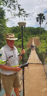
Kevin was the survey guy and came armed with a tripod which housed his GPS base station.
From here, using the US and Russian satellite constellations, he could take ridiculously accurate bearings and heights of anything up to a few kilometres away, and then draw a map that other clever people can use to design water systems with the right volume, pipe diameters, flow rates etc
At the training centre he plotted all the current accommodation...
..and then the land where they hope to build three more clusters.
Claude was Mr. Solar. He looked at everything electrical...
..and placed equipment that recorded power usage in detail.
Here he is in the plane on the way back.
On the last day we visited the school that the mission set up many years ago. We were introduced to an enthusiastic assembly of pupils, some who walk up to three hours to get to school each day.
Kevin took his modern technology to the bush and surveyed the bridge we built six years ago.
We built this bridge after a couple of kids were eaten by crocodiles whilst crossing the river going to school: http://pcm-mercyair.blogspot.com/2014/10/educating-medical-bridge_14.html and http://pcm-mercyair.blogspot.com/2014/12/asam-bridge-dedication.html. Good to see it is still used regularly.A couple of interesting side notes:
On the way up our first port of call for customs/immigration/fuel and a wee was Beira. We arrived there at the same time as an old aircraft that Mercy Air used to operate flew in. Mercy Air operated this 1957 Beech 18 for almost 20 years. I think this was the first time the Beech and the Kodiak, which replaced it, have actually met each other. I wonder which was more jealous?!
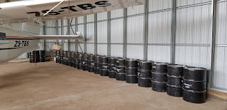
At the end of January we blogged an article about collecting fuel drums which we would use in the case of another natural disaster: http://pcm-mercyair.blogspot.com/2020/01/preparing-for-worst-hoping-for-best.html. It was a long journey for them, but they eventually made it up to central Mozambique and now sit in the missions hangar where we park our aircraft.
Thank you.
Paul and Cathy


No comments:
Post a Comment